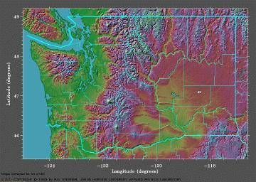
This 3-D map of Washington State shows Owlcroft as the white dot at very roughly 119 degrees longitude and 47 degrees latitude.
This 3-D map of Washington State shows Owlcroft as the white dot at very roughly 119 degrees
longitude and 47 degrees latitude.
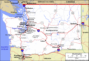
Here, for comparison, is a road map of the State. The City of Ritzville is right at the
intersection of Interstate 90 and US 395, where I-90 turns from southwest to due west.
Ritzville, while a rural town, is not inaccessible: it lies at the juncture of the two most
important Interstate roads in the region,
Interstate 90
and US 395, so auto travel is
remarkably convenient--drive times are one hour to
Spokane (and to
Spokane International Airport, a major airport),
an hour and a half to the Tri-Cities, and four
hours to Seattle. The City even has its own
general-aviation airport (with recent major
reconstruction), not that that matters to us personally.
Overall, the weather is refreshingly four-seasonal with extremes in any season being unusual. The average coldest overnight low is 17 degrees and the average hottest midday high is 91 degrees; rainfall is light, averaging about ten inches a year, and the humidity is correspondingly low. The highest average snow depth in winter is 2½ inches. The average annual heating degree-days figure (base 65) is 6546; the cooling degree-day figure (base 70) is 187.
If you have the patience for a long download, here is full, detailed Ritzville climate data. (Even more such data can be found at the Western Regional Climate Center.)
The inland, east-of-the-Cascades region is dramatically different from the coastal region in many important ways. For example, this region is very stable geologically: earthquakes are virtually unheard of here, and strong earthquakes are literally unheard of, for ages back. Other unpleasant climatic phenomena are also strangers to the region: tornadoes are quite rare (three in Adams County in 120 years, all very mild), while hail storms are unknown here. And the region is even environmentally clean (we used to have a link to an EPA page that demonstrated that, but apparently Big Brother now thinks that Ritzville's cleanliness data is terrorist fodder, and so has taken down that page, and that whole site).
Ritzville averages about 2700 hours of sunshine a year. (A well-designed solar house can get
well over 90% of its annual heating energy from the sun.)